Again, as stated in the previous post Surdex is currently hiring, and for this reason Surdex gets a company profile.
History: http://www.surdex.com/CompanyHistory.aspx
Aircraft: Cessna TU206F (1), Cessna 335 (1), Cessna 404 (1), Cessna 441 (3)
Types of Services: Aerial Photography, Orthophotography, Topographical and planimetric maps, GIS and Lidar.
Major Projects: http://www.surdex.com/RecentProjects.aspx
Look it up and see what Surdex is about.
Monday, January 11, 2010
Company Profile: Surdex
Monday, January 4, 2010
Surdex is Hiring
The link is from USpilot.com and reads:
Details
Title Pilot – Aerial Photography
Description Surdex Corporation, a St. Louis Missouri based, leading nation-wide provider of
aerial photography, and mapping services for federal, state, local governments, and private
industry, is seeking experienced pilots. Preference given to experienced high-altitude Turbine
Photo Pilots with the USDA NAIP program. Candidate must possess at a minimum, COM/INST/MEL
certificate, 1,000 hours PIC, 300 hours multi. Surdex operates C-441, C-404, C-340 & C-206.
Out-of-town travel and deployment required. Competitive pay and benefits. Applications accepted
only via e-mailed cover letter and resume including relevant qualifications and compensation
requirements to: Human Resources, Surdex Corporation, 520 Spirit of St. Louis Blvd.,
Chesterfield, MO 63005 or e-mail to: hr@surdex.com. Visit www.surdex.com EOE/M/F/D/V
for more information sign up for a free account at uspilot.com. I also recommend checking out the Surdex website. The link can be found at the right in the companies worth noting section or at http://www.surdex.com/positionsmoredetails.aspx?id=80. I would get it while it is hot.
Thursday, December 17, 2009
It is a Long Fall!
Six-thousand, Nine-hundred and Thirty-Six Feet from the top exactly. Did you ever wonder what the elevation at the top of the Grand Canyon is, you know..., just in case of a fall? Hopefully this should answer your questions.

You should be okay if you stay away from the edge.
Friday, December 11, 2009
'Up in the Air's' aerial shots took some ingenuity -- latimes.com
The Photography is just beautiful, check it out.
'Up in the Air's' aerial shots took some ingenuity -- latimes.com
Posted using ShareThis
Thursday, December 10, 2009
What is orthophotography and Lidar?
Good Question! What is orthophotography and Lidar?. In today's post we shall delve into the meanings of these terms a little more and hopefully gain a better understanding. First of all lets start with aerial surveying, since that is what a lot of people percieve this profession to be. Aerial surveying in the broad sense of terms can use multiple methods to accurately get the picture. There is as we know aerial surveying to be, which would be the classic photo gained from flying the mission using the flight plan, photo control points, and a fixed film or digital camera such as a leica ads80. The resulting photos can have different traits attributed to them as well. These traits differ based on the customer's needs and usually range from whether they are in color or in black and white even to the resolution needed.

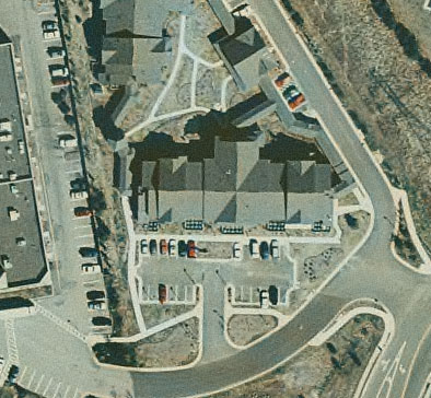
So what is orthophotography then? Well exactly defined orthophotography is a "Photograph having the properties of an orthographic projection. It is derived from a conventional perspective photograph by simple or differential rectification so that image displacements caused by camera tilt and terrain relief are removed." for a list of definitions on this matter visit http://www.maps-gps-info.com/maps-gps-glossary-o.html. To get a better idea of one looks like I have posted a picture to the right for your viewing pleasure.
Lets talk about Lidar shortly. Lidar is how we get topographic maps. Imagine if you wanted to know what the Grand Canyon looked like; to find this out you would look at contours on a map. Imagine that you had to draw everyone of these contours. Instead of having to draw multiple contours, there are sensors that can do this for us. By attaching a sensor to an aircraft, and flying the mission, it is possible to figure out these contours by basically scanning the canyon without actually having to go into it, just by using a laser. Simply explained that is lidar. I highly recommend the article The uses of LiDAR technology.
Basically in brief that is orthophotography and LiDAR. These are both a form or aerial survey. Without the aircraft and the sensors, finding out what our physical earth actually looked like would take longer. In all the technology is there and it works. Without this technology, we would be surveying contours every 50 feet and would not even have a way to see it from the top. Although there is nothing wrong with this, it give those such as engineers, land managers, and GIS databases among others a valuable tool.
Lets talk about Lidar shortly. Lidar is how we get topographic maps. Imagine if you wanted to know what the Grand Canyon looked like; to find this out you would look at contours on a map. Imagine that you had to draw everyone of these contours. Instead of having to draw multiple contours, there are sensors that can do this for us. By attaching a sensor to an aircraft, and flying the mission, it is possible to figure out these contours by basically scanning the canyon without actually having to go into it, just by using a laser. Simply explained that is lidar. I highly recommend the article The uses of LiDAR technology.
Basically in brief that is orthophotography and LiDAR. These are both a form or aerial survey. Without the aircraft and the sensors, finding out what our physical earth actually looked like would take longer. In all the technology is there and it works. Without this technology, we would be surveying contours every 50 feet and would not even have a way to see it from the top. Although there is nothing wrong with this, it give those such as engineers, land managers, and GIS databases among others a valuable tool.
Monday, December 7, 2009
Local Weather Report
Check out the Local Accuweather Weather in the weather widget and you will notice that aerial survey is near impossible here in the southwest. One of the things to consider when planning a mapping mission is how much visibility is required to complete a mission properly. Not only is the visibility less than three miles, the cloud base in most of the southwest is about 2000 feet above the ground. To complicate matters, if ground visibility is important at the time of the mission (and it usually is), then the ground is almost all white today due to continued snowfall. That makes finding those white ground control points slightly difficult, and aerial photography nearly impossible.
Thursday, December 3, 2009
Company Profiles
You will notice that at the top of the page there is a links box titled Aerial Survey Companies Worth Noting. Everyonce in a while there are companies that are distinguishable for some reason or another. It is my intent in this blog to find out what makes them stand apart from the competition. Is it their history, expertise, technology,.... This is what we shall find out together. If you feel that there is a company that should be added to list, feel free to leave a comment. The goal will be to profile one company a month.
Subscribe to:
Posts (Atom)